Proposed New Development at East Farm.
What this might mean for Codford - Have your say
C G Fry & Son and Chapman Lily Planning have proposed up to 60 new homes on agricultural land at East Farm / Chitterne Road (3.73 ha Gross Application Boundary / c. 2.10 ha Net Developable Area). This community advocacy platform provides residents with independent spatial maps, planning evidence, statutory policy tests, and an open-book viability model so our village can take a unified, informed stance.
Online Feedback Deadline
Developer Consultation & Parish Survey
Developer’s Estimated Planning & Delivery Timeline
Published statutory milestones from pre-application consultation to anticipated site completion
Public Consultation
Pre-application consultation on draft proposals. Online feedback closes 5pm, 12 Oct 2026.
Surveys & Review
Further environmental surveys and evaluation of pre-application consultation feedback.
Outline Application
Formal submission of Outline Planning Application to Wiltshire Council.
Determination
Planning determination by Wiltshire Council Strategic Planning Committee.
Reserved Matters
Submission of detailed design, architecture, layout, and landscaping specifications.
Start on Site
Site preparation and commencement of groundworks (subject to planning approvals).
First Occupation
Target date for completion and first residential occupations.
Planning Regulations from 31 October 2026 & Schedule 2 Impact
Major English planning reforms under The Town and Country Planning (Discharge of Local Planning Authority Functions) (England) Regulations 2026 fundamentally change how this 60-home application will be decided.
1. Officer Delegation as Default
Automatic Councillor "call-ins" are abolished. By default, Schedule 2 major developments (10–100 homes) will be determined by delegated planning officers rather than elected committees.
2. The Statutory "Gateway Test"
To secure a public hearing before the Southern Area Planning Committee, the Parish Council must prove the proposal meets the statutory Gateway Test (major policy departure, active travel deficit, and SAC sensitivity).
3. Schedule 2 EIA & SAC Shield
Classed as a Schedule 2 Development under EIA Regulations due to hydrological connection to the River Wylye SAC. Mandatory Habitats Regulations Nutrient Neutrality enforces our 250 PE reed bed wetland requirement.
4. Pre-Determination S106 Mandate
Because case officers hold primary decision power, the Parish Council is locking in the £400k Village Hall Decarbonisation Package, £260k Footway, and 30% Local Housing (18 Homes) directly with planning officers.
Interactive Site & Constraint Explorer
Explore the proposed development boundary, adjacent heritage assets, high-risk groundwater zones, and traffic pinch points. Toggle layers to see spatial constraints.
Geolocation Methodology Caveat & Developer CAD Data Request
Technical Geolocation Context: The layers above represent the Parish Council’s mathematical georeferencing of the unreferenced promotional sketch plan distributed by C G Fry & Son. Because the developer’s leaflet lacks British National Grid (OSGB36) coordinates, scale bars, or survey datum points, vector snapping was performed against authoritative OpenStreetMap and Ordnance Survey ground features (Chitterne Road verge, domestic curtilages, and Beanis Path PROW).
Formal Data Request: Codford Parish Council has formally requested authoritative digital CAD files (DWG/DXF), GIS shapefiles, and topographic survey drawings from the developer. Upon receipt of these engineering datasets, the Parish Council will immediately refine the interactive map to provide the highest achievable survey-grade spatial representation.
Codford Community Survey Results
Empirical evidence and direct feedback gathered from Codford residents and road users regarding the 60-home Chitterne Road / East Farm proposal.
Local residents & road users actively participating.
59.1% Strongly Oppose • 27.3% Major Modifications required.
Demand continuous footway along Chitterne Road.
Demand capital S106 expansion for Codford GP Surgery.
Overall Stance on 60 Dwellings
Community sentiment breakdown
Section 106 Infrastructure Priorities
Ranked by resident consensus percentage
Codford Local Affordable Housing Demand
Existing residents do not have unmet housing requirements, refuting developer claims of massive local shortages.
Specific need identified for young local adults and key workers unable to access local private rentals.
Demand for affordable family homes with local connection ties rather than open-market commuter units.
Verified Resident Testimonies & Local Evidence
First-hand accounts on traffic near-misses, pedestrian hazards, and Chitterne Brook flooding.
Submit Your Evidence to the Parish Council
All responses are stored securely and synthesised anonymously into the Parish Council's official planning objection and evidence dossiers.
Upload Flood Photos, Groundwater Logs & Traffic Evidence
Already completed the survey? Under the 31 October 2026 planning reforms, the Parish Council must submit empirical, date-stamped evidence to satisfy the statutory Gateway Test and guarantee a public hearing before elected Councillors. Please upload photos, dashcam stills, water level logs, or historical documents below.
The 10 Community Red Lines
Based on UK & EU ESG standards, the Parish Council and community establish these non-negotiable requirements for developer negotiations.
Environmental (E)
Chalk Streams, Climate & Dark Skies- Certified Phosphate Neutrality: Mandatory HRA proof protecting the River Wylye (River Avon SAC).
- Dark Sky Reserve Compliance: 0% Upward Light Ratio (ULOR), ≤2700K warm LED lighting only.
- ≥20% Biodiversity Net Gain: Chalk grassland restoration & native hedgerow corridors.
- Future Homes Standard: Fabric-first insulation, rooftop solar PV & zero fossil-fuel heating.
- 13.8m Slope SuDS Attenuation: Climate-stressed (+40%) storm basin capturing steep overland runoff off the 6.5% site gradient before reaching Beanis Path.
Social & Community (S)
Affordability, Safety & Heritage- Strict 30% Affordable Housing: 18 homes with a legally binding Local Connection Cascade for Codford residents.
- Single-Storey Cap on Ridge: Strict height limits on upper contours (98–101m AOD) to prevent 2-storey dwellings towering 26m over Beanis Path cottages.
- Adopted Footway on Chitterne Rd: Continuous safe pavement connecting site directly to High Street.
- ANZAC Cemetery & Church Buffer: Acoustic & visual screening protecting war memorial sanctity.
- GP Surgery & School S106 Sums: Ring-fenced funding to expand local patient and school capacity.
- Village Hall Decarbonisation & Renewal (£400k): Dedicated capital support for replacement roof, external cladding, insulation, and solar PV array.
Governance (G)
Stewardship, Open Data & No Fleecehold- Freehold Transfer of Community Orchard: Ownership deeded to Parish Council with endowed maintenance.
- Ban on Unregulated Management Fees: Preventing private "fleecehold" charges on future residents.
- Open Technical Data Disclosure: Full access to borehole logs, drilling results, and traffic counts.
- Open-Book Viability: Mandatory public scrutiny if the developer attempts to reduce affordable housing.
Developer Return & S106 Viability Calculator
Test the financial viability of the 60-home scheme under statutory UK Planning Practice Guidance (PPG). Adjust market sales prices, construction costs, and community infrastructure to see the resulting developer profit and land value surplus in real time.
Cost & Revenue Assumptions
Financial Feasibility Summary
Why the Parish Council Is Engaging the Community in This Manner
A critical question for residents across Codford St Peter and Codford St Mary is: "Why is the Parish Council launching this digital advocacy platform now, in the absence of an adopted Neighbourhood Plan or current Village Plan?"
The Statutory Planning Risk: Speculative Development & the "Tilted Balance"
Under UK planning law, when a parish does not have an active, adopted Neighbourhood Development Plan (NDP) allocating specific housing sites, commercial developers frequently target unallocated greenfield land through speculative planning applications. If local authority housing land supply is contested, national planning policy triggers the "presumption in favour of sustainable development" (NPPF Paragraph 11) - tilting the planning balance towards granting permission unless adverse impacts significantly and demonstrably outweigh the benefits.
Levelling the Technical Playing Field
Housebuilders arrive armed with expensive planning barristers and transport consultants. This portal equips every resident with professional planning evidence and policy benchmarks.
Authoritative Community Evidence
General emotional complaints carry little weight with planning inspectors. Material planning representations citing Wiltshire Core Policies and Habitats Regulations carry decisive legal weight.
Binding Section 106 Heads of Terms
If development proceeds, our community must secure maximum legal benefits: 30% local-cascade affordable homes, surgery expansion funding, and freehold parish open space.
Democratic Village Unity
Structured survey feedback enables the Parish Council to represent the unified, verified will of the entire village at Wiltshire Council planning hearings and public inquiries.
The Basis of ESG in UK Planning Law & Sustainable Development
In modern corporate governance, ESG represents Environmental, Social, and Governance. In the context of British town and country planning, ESG is not marketing jargon - it is directly rooted in the statutory test of Sustainable Development set out in Paragraph 8 of the National Planning Policy Framework (NPPF), the Wiltshire Core Strategy, and UK environmental statutes:
Environmental Stewardship
- River Wylye SAC Nutrient Neutrality: Under the Conservation of Habitats and Species Regulations 2017 and Core Policy 69, new dwellings must achieve certified zero-net phosphorus export to protect fragile chalk river ecology.
- Mandatory 10% Biodiversity Net Gain (BNG): Mandated by the Environment Act 2021, requiring measurable on-site habitat enhancement via the statutory Defra metric.
- Cranborne Chase Dark Sky Reserve: Strict lighting controls (0% Upward Light Ratio, max 2700K warm luminaires) under NPPF Paragraph 191.
- Chalk Hydrogeology & SuDS: Drainage attenuation sized for 100-year storm events (+40% climate allowance) with seasonal groundwater safeguards.
Social Equity & Community
- Strict 30% Affordable Housing (Core Policy 43): 18 of 60 homes secured without viability clawback, governed by a legally binding Codford Local Connection Cascade.
- Healthcare, Primary School & Village Hall: S106 capital contributions to expand the Codford GP Surgery clinical space, school classrooms, and £400k decarbonisation/renewal for Codford Village Hall (roof, cladding, insulation & solar PV).
- Highway Safety & Active Travel (NPPF Section 9): Mandatory Section 278 adopted continuous footway along Chitterne Road to the High Street.
- Heritage Setting (NPPF Section 16): Safeguarding the rural solemnity of Grade II* St Mary's Church and the ANZAC Commonwealth War Graves Cemetery.
Governance & Accountability
- Pre-Application Scrutiny (NPPF Paragraphs 39–46): Meaningful community consultation rather than a superficial tick-box PR exercise.
- Enforceable Section 106 Heads of Terms: Binding all developer commitments in legally watertight planning obligations with performance bonds.
- Parish Freehold Dedication: Freehold transfer of the proposed Community Orchard and SuDS meadow to the Parish Council with a 20-year maintenance endowment.
Planning Policy Matrix: Context, Requirements & Potential Conflicts
This matrix evaluates the proposed development of up to 60 dwellings off Chitterne Road against current English planning law, the National Planning Policy Framework (NPPF), the Wiltshire Core Strategy, emerging Local Plan policies to 2038, and statutory environmental legislation. It identifies where the proposal creates key policy tensions and specifies the mandatory legal resolution mechanisms required.
| Policy Domain & Level | Statutory & Local Policy Benchmark | Development Proposal Context | Potential Policy Conflict / Tension | Mandatory S106 / Condition Mechanism |
|---|---|---|---|---|
| Spatial Principle Settlement Hierarchy & Land Supply |
Wiltshire Core Policy 1 & 2: Codford is designated a 'Large Village'. Development is restricted to infill / allocated sites within settlement boundaries. NPPF Paras 11, 60–70: Presumption in favour of sustainable development; delivering rural housing. |
60 dwellings on 3.73 ha gross / c. 2.10 ha net developable agricultural greenfield located outside the current Limits of Development for Codford St Mary. | ⚠️ Core Policy 2 Conflict Unallocated countryside site. Developer may argue housing land supply shortfalls to invoke NPPF Paragraph 11 "tilted balance". | Mandatory Demonstration: Must prove exceptional community need, deliver 30% local-cascade housing, and demonstrate no unacceptable landscape harm. |
| Social Equity Affordable Housing & Local Cascade |
Wiltshire Core Policy 43: Mandates minimum 30% on-site affordable housing in the Warminster Community Area without exception. NPPF Paras 63–65: Provision of affordable homes meeting identified local rural needs. |
Developer leaflet proposes an unspecified mix of "market and affordable homes" across the 60 units. | ⚠️ Viability Clawback Risk Risk of post-acquisition financial viability appraisal seeking to reduce affordable quota below 30% or skew tenures away from affordable rent. | Binding S106 Cascade: 18 units legally secured (60% affordable rent / 40% first homes/shared ownership) with strict Codford Parish Local Cascade in perpetuity. |
| Highways & Safety Pedestrian Access & Active Travel |
Wiltshire Core Policy 60, 61 & 62: Safe access, sustainable transport integration, and pedestrian connectivity. NPPF Paras 114–116: Safe and suitable access for all users; priority to pedestrian/cycle movements. |
Single vehicular access onto Chitterne Road. No existing continuous footway connects the site south to the High Street. | ⚠️ Severe Road Hazard 150+ residents forced to walk in the live carriageway on a derestricted/30mph blind bend to access schools, shops, and surgery. | Grampian S278 Condition: Delivery of an adopted, continuous, illuminated pavement along Chitterne Road to High Street prior to first residential occupation. |
| Ecology (Statutory) River Wylye SAC Nutrient Neutrality |
Conservation of Habitats & Species Regs 2017: Reg 63 Appropriate Assessment required. Zero-net phosphorus loading. Wiltshire Core Policy 69: Protection of the River Avon Special Area of Conservation (SAC). |
60 dwellings generating domestic wastewater discharging into the River Wylye / River Avon SAC catchment. | ⚠️ Absolute Legal Veto Unmitigated wastewater phosphorus will fail the Habitats Regulations test, causing unlawful nutrient pollution in rare chalk river habitats. | Certified Mitigation: Natural England approved phosphorus neutrality budget and legally secured off-site catchment mitigation prior to determination. |
| Hydrology Groundwater Surge & SuDS Design |
Wiltshire Core Policy 67: Flood risk assessment; priority for sustainable urban drainage (SuDS). NPPF Paras 165–175: SuDS required on all major developments with 100yr + 40% climate allowance. |
Single proposed surface water attenuation pond located in southern field depression on Salisbury Plain Upper Chalk bedrock. | ⚠️ Groundwater Flooding Risk Unlined infiltration basins fail during winter groundwater surge, causing surface flooding and surcharge into public sewers. | Empirical Borehole Mandate: Mandatory winter groundwater monitoring, micro-drainage modelling, impermeable lined attenuation, and parish adoption safeguards. |
| Landscape Dark Sky Reserve & National Landscape |
Wiltshire Core Policy 51: Conserving landscape character of Cranborne Chase AONB / National Landscape. NPPF Paras 182 & 191: Great weight to conserving National Landscapes; limiting light pollution. |
60 residential plots, internal estate lighting columns, and domestic floodlights on elevated village edge. | ⚠️ Dark Sky Degradation Suburban skyglow threatening Cranborne Chase International Dark Sky Reserve (IDSR) status. | Cranborne IDSR Covenants: Strict 0% Upward Light Ratio (ULOR), max 2700K warm luminaires, PIR curfew timers, and dark sky title deeds. |
| Historic Heritage St Mary's Church & ANZAC War Graves |
NPPF Section 16 (Paras 195–214): Conserving significance and setting of designated heritage assets. Section 66(1) Planning Act 1990: Special regard to preserving listed building settings. |
Southern boundary abuts the Grade II* St Mary's Church precinct and Commonwealth War Graves Commission ANZAC Memorial Cemetery. | ⚠️ Setting & Solemnity Harm Visual and acoustic intrusion disturbing the quiet contemplation and historical setting of war graves and church. | 100m Woodland Buffer: Legally covenanted 100m native woodland acoustic buffer, restrictive height controls, and perpetual cemetery seclusion. |
| Rights of Way & BNG Beanis Path & Biodiversity Gain |
Environment Act 2021: Mandatory minimum 10% Biodiversity Net Gain (BNG) via statutory Defra metric. Wiltshire Core Policy 50 & NPPF Para 104: Protection and enhancement of public rights of way. |
Housing layout traverses across the historic diagonal Beanis Path PROW corridor (OSM Way 858070815).
|
⚠️ PROW Severance Risk of urbanising, diverting, or degrading the ancient walking route between Chitterne Road and Church Lane. | Enhanced Active Corridor: Retention and enhancement of Beanis Path as an un-diverted green corridor + Freehold transfer of Community Orchard to Parish Council. |
| LiDAR Topography Slope, Overlooking & Amenity |
Wiltshire Core Policy 57: High quality design, place shaping, and safeguarding residential privacy & amenity. Core Policy 67: Flood risk, overland flow paths & sustainable drainage. |
EA 1m LiDAR confirms 18.58m (61.0 ft) vertical fall (7.6% slope). Dwellings on upper contours (100m AOD) will have rooflines at 108.5m AOD. | ⚠️ Acute Overlooking & Runoff Upper-terrace 2-storey dwellings towering 26m over Beanis Path homes, plus steep overland flow wash into southern gardens. | Single-Storey Cap & Upsized SuDS: Single-storey height cap on upper contours, stepped terracing, 15m landscape buffer to Beanis Path, and upsized storm attenuation. |
Evaluating Sustainable Development & Potential Wider Community Benefits
1. The Sustainable Development Balance (NPPF Paragraph 8)
Under national planning policy, achieving sustainable development requires balancing three mutually reinforcing objectives: economic, social, and environmental. The planning policy matrix above demonstrates that while the proposal brings economic activity during construction, it introduces substantial tensions with environmental and spatial development plan policies - most notably settlement hierarchy restrictions (Core Policy 2), River Wylye SAC phosphate limits (Core Policy 69), and pedestrian safety deficits along Chitterne Road.
However, the Parish Council’s role is not simply to register a blanket refusal. By applying the ESG framework rigorously, the Parish Council can hold the developer to the highest standards of planning law, determining whether the proposal can be reshaped to deliver genuine, lasting community benefit.
2. Potential Wider Community Benefits (The 'Win-Win' Scenario)
If the applicant complies strictly with the statutory mitigation mechanisms outlined in the policy matrix, the scheme could deliver transformative infrastructure upgrades that Codford has sought for decades:
24 genuinely affordable homes secured under a legally binding Codford Local Cascade would allow young village families and local key workers to remain in Codford rather than being priced out.
A developer-funded Section 278 adopted continuous pavement would resolve a dangerous historic highway hazard, allowing pedestrians to walk safely from the north of the village to the High Street.
Transferring the ~2-hectare Community Orchard and SuDS meadow into public Parish Council freehold ownership with a 20-year endowment secures permanent recreational open space for generations.
Ring-fenced Section 106 capital contributions would fund clinical expansion at the Codford GP Surgery and additional classroom capacity at Codford Primary School.
3. The Pre-Application Strategy: "Comply or Refuse"
The Parish Council's strategy ahead of the 28th September 2026 public exhibition is clear: we establish our 10 Community Red Lines early and unambiguously. If C G Fry and Chapman Lily Planning integrate these binding Section 106 Heads of Terms, certified nutrient neutrality, and highway solutions into their final submission, the development can achieve compliance with the statutory test of sustainable development. If they refuse or attempt to dilute these obligations through viability loopholes, this policy matrix provides the Wiltshire Council Planning Committee and Planning Inspectorate with an unassailable legal basis for planning refusal.
Stewardship vs Speculative Commodification
1. Intergenerational Equity (Brundtland Principle): Sustainable development means meeting present needs without stealing from future generations. Converting open chalk downland into asphalt is irreversible; once built upon, that rural heritage is gone forever.
2. The Precautionary Principle: Where serious environmental risks threaten chalk aquifers, groundwater flooding, or SAC habitats, the burden of proof rests entirely on the developer.
3. Nature-Positive Commons: Land is not merely an investment asset on a balance sheet; it is a living ecosystem supporting chalk hydrology, biodiversity, and community well-being that must be handed over in a healthier state.
How This Portal & Map Were Constructed
• Survey-Grade Vector Geomatics: Rather than pasting distorted PDF images over satellite tiles, engineers extracted raw vector coordinates directly from OpenStreetMap (OSM) and Ordnance Survey OpenData for Codford St Mary.
• Beanis Path Recovery (OSM Way 858070815): Mapped the exact historical Public Right of Way running diagonally across the site from Chitterne Road to Church Lane.
• Property Curtilage Protection: Precisely traced domestic boundaries around the Old Police House (Way 1369910878) and Oxyard Cottages (Ways 1369910871–1369910876).
• 100% Open Public-Interest Tech: Built using client-side open web standards (Leaflet GIS, GeoJSON, Tailwind CSS) with zero corporate tracking.
Challenges of Unreferenced Sketch Plans: The indicative masterplan circulated by the developer is an unreferenced promotional sketch lacking British National Grid (OSGB36) coordinates, geodetic survey control points, or engineering scale anchors. Snapping an unreferenced artistic graphic to authoritative GIS data involves resolving inherent perspective distortions and line-weight ambiguities.
Parish Council Data Request: Codford Parish Council has formally requested authoritative digital CAD files (DWG/DXF), GIS shapefiles, and raw topographic survey data from C G Fry & Son and Chapman Lily Planning. Upon receipt of these engineering datasets, the Parish Council will immediately enhance and refine the interactive spatial layers on this portal to provide the highest achievable survey-grade precision.
Key Documents & High-Res Maps
Download original developer flyers, individual councillor notification letters, high-resolution constraint maps, and technical briefings.
Methodology & ESG Guide
How the map was constructed, ESG in UK planning law, and community advocacy strategy.
Read GuideDeveloper Consultation Leaflet
Complete consultation flyer circulated by C G Fry & Son and Chapman Lily Planning.
Download PDFPristine Site Masterplan
High-resolution uncompressed masterplan showing 60-home layout, SuDS, and road loop.
View High-ResBeanis Path Street Elevation
Architectural street scene elevation showing proposed dwelling heights and vernacular.
View ElevationOS Context Plan
Ordnance Survey base context map showing redline boundary against surrounding fields and lanes.
View MapLiDAR Elevation Profile
1m EA LiDAR bare-earth slope cross-section showing 13.8m (45ft) site cross-fall to Beanis Path.
View ProfileCouncillor Invitation Letters
Formal notification letter sent to Parish Councillors by Chapman Lily Planning.
Download Letter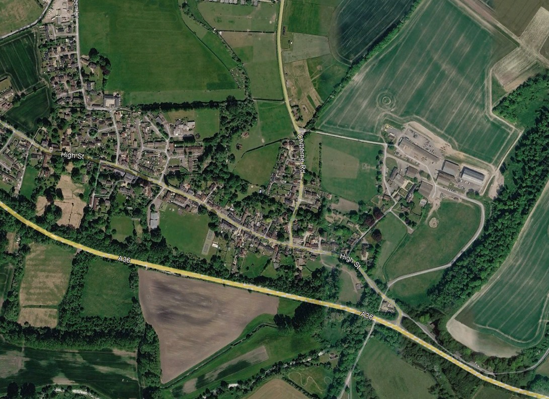
Material Planning Comment Generator
Planning inspectors and council officers only evaluate Material Planning Considerations. Use this tool to select your key concerns and generate a legally grounded submission ready to send to Chapman Lily Planning and Wiltshire Council.
1 Select Your Material Planning Concerns
2 Your Details (Optional for Letterhead)